
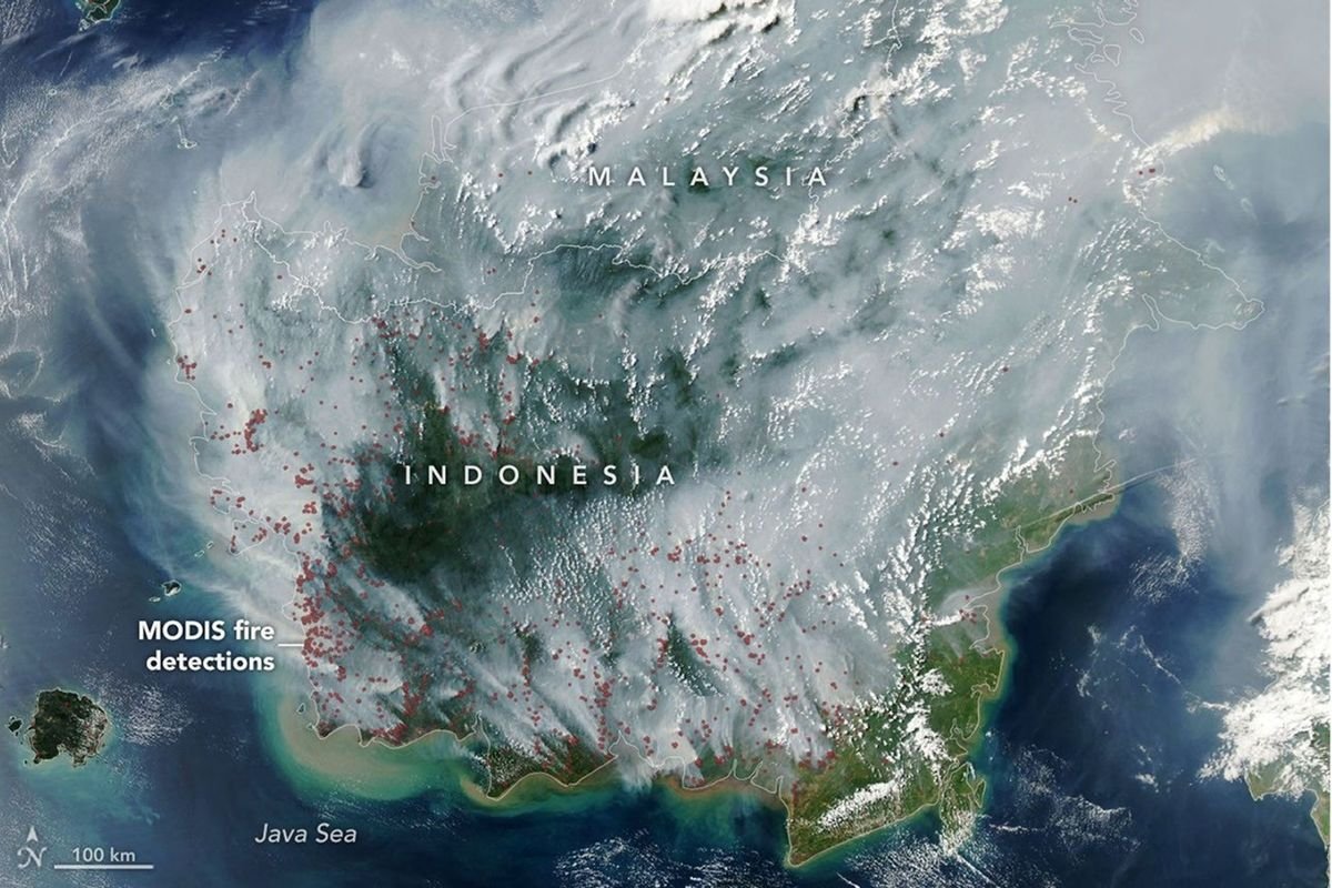
ZOAHARIAN.COM – Forest and land fires (karhutla) have become a concern again after NASA satellite images recorded clouds of smoke covering several parts of Indonesia. The smoke was seen quite widely, especially in the area of Kalimantan Island, and was even observed moving to reach the territory of the neighboring country, Malaysia.
In the satellite image, a number of red dots can be seen scattered over the land area. These dots show heat anomalies (hotspots) detected by the Moderate Resolution Imaging Spectroradiometer (MODIS) instrument on NASA's Aqua satellite.
This heat anomaly is an indicator of fire activity on the surface. The more hot spots detected in an area, the stronger the indication that the area is experiencing fire activity, although the existence of hotspots still requires verification in the field.
The plume of smoke captured from outer space shows how forest and land fires are not only a problem around fire locations. If it occurs on a large scale and atmospheric conditions are favorable, the smoke can be carried by the wind across areas far from the source of the fire.
Forest and Forestry Smoke Could Cross the Country
This condition also has the potential to cause cross-border impacts. Smoke from fires in Indonesia can be carried by the wind towards Malaysia and other regions, especially when the direction and speed of the wind supports the movement of air masses.
This phenomenon is not the first time Indonesian forest and land fire smoke has impacted neighboring countries. Wide-scale fires in Sumatra and Kalimantan have previously caused air quality to deteriorate in a number of areas in Indonesia, Malaysia and Singapore.
Satellite imagery is an important technology for monitoring the development of forest and land fires. Data from satellites can help show locations that have indications of heat as well as provide an idea of the distribution of smoke.
The Threat Isn't Just Fire
Forest and land fires do not only threaten forest and land areas. The smoke produced can reduce air quality and disrupt community activities, especially in areas close to the center of the fire or smoke movement routes.
Therefore, monitoring hotspots via satellite is an important part of efforts to detect and handle fires as early as possible.
The NASA recording also shows that fires in one area can develop into a wider problem. When smoke begins to cover the area on a large scale and crosses national borders, handling forest and land fires requires fast coordination and response
Comment (0)
No comments yet. Be the first!
Leave a Comment